

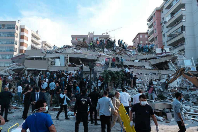
Cameras were still rolling when a massive 7.8 quake turned a quiet Philippine morning into chaos, offering a stark reminder of how fragile modern life — and global supply chains — really are.
Story Snapshot
- A magnitude 7.8 offshore earthquake struck southern Mindanao, killing at least dozens and injuring more than 200 people.
- CCTV footage shows buildings, bridges, and schools shaking apart in seconds as panic erupts in General Santos and nearby provinces.
- The quake triggered tsunami alerts across the region and exposed how quickly critical infrastructure can fail.
- For Americans, the event underscores why resilient infrastructure, secure supply chains, and honest crisis reporting matter to national security and the economy.
Massive Quake Strikes Mindanao As Cameras Capture The Moment
On June 8, a powerful magnitude 7.8 earthquake struck off the southern coast of Mindanao, the Philippines’ second-largest island, shaking the region for roughly 30 seconds and sending terrified residents running into the streets.[1][3] Seismologists located the epicenter offshore near Sarangani province, west-southwest of the coastal town of Kablalan, in waters south of the commercial hub of General Santos City.[1][3] Closed‑circuit television cameras in homes, shops, and schools recorded ceilings swaying, walls cracking, and people scrambling for cover as everyday routines instantly collapsed into fear.[3]
Philippine and international monitoring agencies, including the Philippine Institute of Volcanology and Seismology and the United States Geological Survey, agreed the event was among the strongest to hit the country in decades, with moment magnitude estimates centered around 7.8 and a focal depth on the order of several dozen kilometers.[1][3] The quake originated along the complex tectonic structures off Mindanao’s southern coast, an area long recognized as seismically active and capable of triggering both strong ground shaking and secondary hazards such as landslides and tsunamis.[1][2] For local residents, there was no warning beyond the sudden violent motion caught on camera.
Casualties Mount As Buildings, Bridges, And Schools Fail
Initial reports from local authorities and international media tallied at least four deaths and more than 200 injuries in the hours after the quake, mostly from collapsing structures and falling debris in General Santos and neighboring provinces.[1][3] As damage assessments expanded into more remote communities and landslide areas, later government and media accounts indicated the death toll climbed into the dozens, with at least 32 fatalities and more than 200 injured across Mindanao.[1] A significant share of the casualties came from a deadly landslide in Glan, Sarangani province, where 13 people were reported killed when unstable hillsides gave way.[1][2]
Damage reports reveal a pattern that will sound familiar to Americans who worry about aging bridges and brittle infrastructure: at least 37 structures were recorded damaged across Mindanao, including commercial buildings, schools, hospitals, residential homes, and government facilities.[1] In General Santos, small buildings partially collapsed, a key access bridge developed serious cracks, and debris rained down on vehicles and pedestrians.[3] In South Cotabato, sections of road cracked and a bridge failed, closing a highway link between T’Boli and General Santos and highlighting how a single event can choke transportation lifelines.[1] Power, water, and internet service were disrupted in several cities and towns, demonstrating the cascading impact when critical systems are not resilient.[1]
Tsunami Alerts, Aftershocks, And A Region On Edge
Within minutes of the main shock, tsunami centers and disaster agencies across the Pacific sounded the alarm, issuing warnings and advisories for southern Philippine coasts as well as parts of Indonesia, Palau, Japan, Taiwan, and Papua New Guinea.[1] Tide gauges and local monitoring stations later confirmed tsunami waves along Mindanao’s southern shoreline, with Philippine instruments measuring waves up to roughly 1.4 meters in several coastal areas between 7:42 and 8:45 in the morning.[1] Smaller waves, generally under half a meter, were detected at multiple Indonesian coastal stations, validating that the offshore rupture had displaced enough water to generate a basin‑wide response.[1][2]
🇵🇭 Major M7.8 earthquake hits the southern Philippines
On Monday, June 8, 2026, at 7:37 a.m. local time, a major M7.8 earthquake struck the Celebes Sea near southern Mindanao. According to the USGS, the epicentre was located 26 km southwest of Cablalan, with a hypocentre at a… pic.twitter.com/PW0Q4CdJ8J
— Windy.com (@Windycom) June 8, 2026
Even after the initial shaking stopped and the worst tsunami fears eased, residents faced relentless aftershocks and uncertainty.[1][3] Philippine scientists documented at least 180 aftershocks in the hours and days that followed, including several events above magnitude 6.0 and another close to magnitude 5.8.[1] These follow‑on quakes further destabilized already damaged buildings, complicated search and rescue operations, and kept families sleeping outside or in makeshift shelters instead of their homes.[1][2] For many, the threat did not feel over once the cameras stopped recording; it simply shifted from one kind of risk to another.
Why This Distant Disaster Matters To American Conservatives
Although this tragedy struck far from American shores, the images replayed from Philippine closed‑circuit footage should resonate with anyone concerned about the vulnerability of modern life and global systems. General Santos is a major commercial center and tuna‑processing hub, connected to international markets that include the United States.[3] When its bridges crack, airports pause, and power grids fail, the shock does not stay local; it ripples into supply chains, commodity prices, and trade flows that U.S. consumers and businesses depend on.[1][3] Conservative voters who value secure borders, reliable infrastructure, and energy independence can see in Mindanao’s experience a warning about ignoring physical realities.
The earthquake also illustrates how early reporting during crises often produces conflicting numbers and fragmented narratives, with death tolls and damage estimates shifting as officials verify information from remote or heavily hit communities.[1][2][3] That instability is not unique to foreign disasters; it is the same challenge Americans face when trying to discern fact from noise in the first hours after any major event. For an audience wary of politicized coverage and globalist spin, the Mindanao quake is a reminder of why transparent data, robust local capacity, and honest, accountable institutions matter — both abroad and at home — when the ground literally moves under people’s feet.
Sources:
[1] YouTube – CCTV footage shows moment magnitude 7.8 earthquake hit the Philippines
[2] Web – 7.8-magnitude earthquake in southern Philippines causes 4 deaths, …
[3] Web – Earthquake of magnitude 7.8 strikes off southern Philippines, 15 …
© standardheadlines.com 2026. All rights reserved.